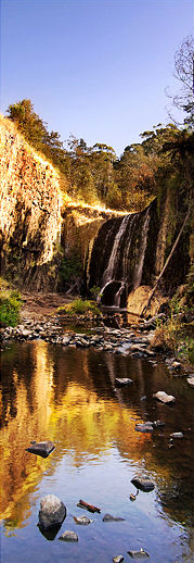
Guide Falls
Appearance
| Guide Falls | |
|---|---|
 Guide Falls, in summer 2007. | |
 | |
| Location | North West Tasmania, Australia[1] |
| Coordinates | 41°09′00″S 145°48′00″E / 41.15000°S 145.80000°E[2][3] |
| Type | Tiered–cascade |
| Elevation | 187 metres (614 ft)[4] AHD |
| Total height | 22–38 metres (72–125 ft)[4] |
| Watercourse | Guide River |
The Guide Falls and Upper Guide Falls, a tiered–cascade waterfall on the Guide River, is located in the North West region of Tasmania, Australia.[1]
Location and features
[edit]The waterfalls are situated about 19 km south of Burnie[5] at an elevation of 187 metres (614 ft) above sea level and descend in the range of 22–38 metres (72–125 ft).[4]
See also
[edit]References
[edit]- ^ a b "Guide Falls reserve, Ridgley: Must do!". think-tasmania.com. 15 February 2013.
- ^ "Guide Falls (TAS)". Gazetteer of Australia online. Geoscience Australia, Australian Government.
- ^ "Upper Guide Falls (TAS)". Gazetteer of Australia online. Geoscience Australia, Australian Government.
- ^ a b c "Map of Guide Falls, TAS". Bonzle Digital Atlas of Australia. Retrieved 31 May 2014.
- ^ "Guide falls". discoverburnie.net. Retrieved 25 January 2020.

